What Makes This Site Extraordinary
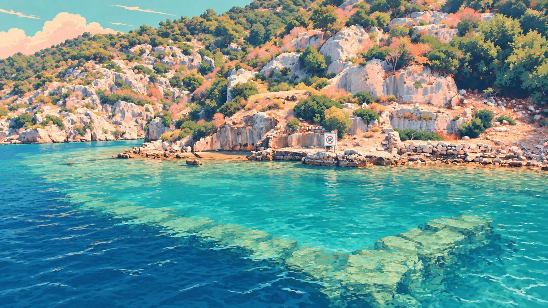
Imagine looking down from a slow-moving boat and seeing the floor plan of an entire ancient neighbourhood — stone walls marking out rooms, stairways descending to what was once a waterfront, cisterns still holding their shape after two thousand years. That's not a hypothetical. That's what you see at Kekova on a clear morning.
The sunken city is the submerged remains of Dolichiste, a Lycian port town that occupied the southern shore of Kekova Island until a 2nd-century earthquake dropped the coastline between 1 and 3 metres below sea level. It is widely regarded as the best-preserved sunken city in Turkey — and one of the most accessible in the entire Mediterranean. What would have crumbled to rubble on dry land was instead sealed beneath salt water, preserved in what underwater archaeologists sometimes describe as “accidental conservation” — the destruction that saved it.
This isn't a museum behind glass. It's a living seascape where ancient walls sit beneath boats that pass daily, where fish swim through former doorways, and where the quality of your experience depends entirely on timing, conditions, and knowing what to look for. This guide covers all three.
This guide focuses on the present-day experience — what you'll see and how to see it. For the full story of how Dolichiste was founded, why it sank, and what happened to the other two cities around the bay, see our dedicated Kekova History →
What's Visible: Kekova's Underwater Ruins Up Close
The submerged district stretches along approximately 500 metres of Kekova Island's southern coast. Underwater surveys conducted since the 1970s — most recently using photogrammetric mapping and 3D modelling — have confirmed at least two distinct building phases: an earlier Lycian/Hellenistic settlement and a later Roman expansion. The ruins lie between 1 and 3 metres below the current waterline — shallow enough to see clearly from a boat or kayak, but deep enough that the structures have been protected from wave action and storm damage. Here's what to look for.
Harbour Quay Walls
The most immediately visible structures are the harbour walls — long, straight runs of cut stone that once formed the quayside where boats loaded and unloaded goods. These walls are built from large limestone blocks, precisely fitted in the Lycian style, and they extend parallel to the modern shoreline for dozens of metres. On calm mornings, the wall courses are so crisp that you can count individual stone blocks from the surface.
Stairways and Doorways
Perhaps the most evocative feature. Several stone stairways descend from rock-cut doorways on the surviving island shore down into the water — leading to what were once ground-level streets. These stairways were the front doors of waterfront houses and workshops, and their preservation is remarkable: individual treads are still intact, some with the wear patterns of centuries of foot traffic visible as shallow depressions in the stone.
House Foundations and Room Plans
Looking down from above, you can trace the outlines of individual buildings — rectangular room divisions, wall junctions, and in some cases the outlines of what appear to be multi-room residential complexes. The Roman-era structures are distinguishable from the earlier Lycian buildings by their more regular geometry and the use of hydraulic concrete in certain wall sections — though this level of detail requires very clear water and a low boat or kayak.
Water Cisterns
Kekova Island had no freshwater springs, so the residents of Dolichiste depended on rock-cut cisterns to collect and store rainwater. Several of these cisterns are visible beneath the surface — roughly circular or rectangular depressions in the rock with smoothly plastered interior walls. The Roman-era examples used opus signinum, a waterproof plaster mixed with crushed pottery that has survived remarkably well in the underwater environment.
Sarcophagus Fragments and Funerary Stone
Scattered among the residential ruins are fragments of Lycian sarcophagi — the distinctive peaked-lid stone coffins found across the Lycian coast. Most are broken, their lids dislodged by the earthquake or by centuries of wave action, but several base sections remain in place on the seabed. You'll also spot loose architectural fragments: column drums, carved lintels, and threshold stones that were displaced when the buildings they belonged to collapsed during the subsidence. These pieces are easiest to identify in the shallower western section near the harbour entrance, where they sit on a relatively clear, sandy bottom.
Three Key Viewing Points Along the Boat Route
Boat tours from Üçağız pass along the sunken city at reduced speed, but guides don't always explain exactly what you're seeing. Here are the three sections to watch for, in the order most boats encounter them travelling west to east along the island's southern shore.
Point 1: The Harbour Entrance
The western end of the submerged district, where the ancient harbour opened to the sea channel between the island and the mainland. Look for two parallel walls extending outward from the shore beneath the water — these are the harbour breakwaters, designed to protect moored boats from currents. Between them, the harbour basin is visible as a shallow depression with a relatively flat, silted bottom. This is usually the first major structure boats pass, and it's an excellent orientation point: once you've identified the harbour walls, the rest of the submerged district makes more spatial sense.
Point 2: The Stairway Section
Approximately 200 metres east of the harbour entrance, the coastline rises slightly and the surviving shore-level structures include several rock-cut doorways with descending stairways. This is the most photographed section of the sunken city — the stairways create a dramatic visual because they clearly connect the above-water terrain (the island's rocky slope) with the below-water structures (the former street level). On very still days, the treads of the stairways cast shadows in the shallow water that make them visible even from a passing boat.
Point 3: The Cistern Area
The eastern section of the submerged district contains several of the rock-cut cisterns described above, along with the densest concentration of house foundations. This area is slightly deeper — around 2 to 3 metres — and the ruins are best viewed on very clear days when the sunlight penetrates at a steep angle (mid-morning is ideal). The room outlines here are among the most legible in the entire site, and on exceptional days you can see the line where plastered cistern walls meet the natural rock.
Most boat captains slow down through the stairway section because it's the most visually dramatic, but they sometimes speed past the cistern area at the eastern end. If you're on a group tour and your captain is starting to accelerate, ask politely (“Yavaş gidebilir miyiz?” — “Can we go slowly?”). Most captains are happy to oblige if asked. On a private boat or sea kayak, you set your own pace entirely.
Viewing From Above: Kaleköy and the Castle
There's a perspective on the sunken city that most visitors miss entirely: the view from above. From the ramparts of Simena Castle in Kaleköy, you look almost directly down onto the channel between the mainland and Kekova Island. On calm, clear mornings, the submerged wall lines of Dolichiste are visible as dark geometric patterns against the lighter sandy seabed — an outline of an entire neighbourhood drawn in stone beneath the surface.
This aerial perspective reveals something that's invisible from boat level: the scale of the submerged district. From the water, you see individual walls and stairways. From above, you see the grid — the overall layout of a planned settlement with streets, blocks, and harbour infrastructure. It's the difference between reading a sentence and seeing the whole page.
When to Go: Timing and Conditions
Time of Day
The window between 8am and 10am is ideal for three reasons: the wind hasn't picked up yet (afternoon imbat breezes typically start around 11am and create surface chop), the sun is high enough to illuminate the underwater structures but low enough that direct overhead glare isn't a problem, and the first boats of the day haven't yet churned sediment from the seabed. If you're choosing between a morning and an afternoon tour, the morning is always better for the sunken city.
Season
May through June and September through October are the sweet spot. The water is warm and clear, the crowds are smaller than peak July–August, and the winds tend to be calmer. July and August bring the highest tourist density — meaning more boats, more wake, more disturbed sediment, and a narrower window of clear conditions. Winter months (November–March) have fewer boats but rougher seas and shorter daylight hours.
The Polarised Sunglasses Effect
This is the single most impactful piece of equipment you can bring. Polarised lenses cut surface glare by filtering horizontally reflected light, transforming a glinting, opaque water surface into a clear window. Without them, you'll see vague dark shapes. With them, you'll see individual stone courses, stairway treads, and the plastered interiors of cisterns. The difference is genuinely dramatic — like switching from a blurred photograph to a high-resolution image.
I've taken dozens of people to the sunken city. The ones who remember it most vividly are always the ones who happened to have polarised sunglasses. It's the single cheapest upgrade that makes the biggest difference to the experience.
DenizProtection Rules: What You Can and Can't Do
Kekova was designated a Specially Protected Area (SPA) in 1990 — one of Turkey's first marine conservation zones. The rules exist because, before them, the site was deteriorating. Boat anchors damaged walls, swimmers touched and dislodged stones, amateur divers removed artefacts, and engine pollution clouded the water. The 1990 regulations reversed that trajectory.
No swimming in the sunken city zone. No diving or snorkelling. No anchoring near the ruins — boats must use designated mooring points. Speed limit enforced — boats must pass at slow speed through the protected stretch. No drone flights over the SPA. No removal of any material, including loose stones, pottery fragments, or marine life. Violations are enforced by Coast Guard patrols and can result in fines and equipment confiscation.
For context: the swimming ban applies specifically to the sunken city protection zone along the island's southern shore. It does not apply to the entire bay. Tersane Bay, Akvaryum Bay, and several other coves within the Kekova area are open for swimming, and most boat tours include a swim stop at one or more of these bays as part of their standard route. You won't leave Kekova without having been in the water — just not directly over the ruins.
In the early 90s, before the rules were strictly enforced, people would jump off boats and swim directly over the ruins. Some reached down and touched the ancient walls — a few even chipped off pieces as souvenirs. I understand the impulse: when you're that close to 2,000-year-old stonework, the urge to touch it is primal. But the cumulative effect of thousands of hands, thousands of fins, and thousands of anchors was measurable damage. The boat captains who initially resented the ban now support it. Without it, there'd be far less left to show tourists — and far less reason for tourists to come.
Photography Tips
Photographing underwater ruins from above the surface is technically challenging. The water acts as a filter, a mirror, and a distortion lens simultaneously. Here's what works.
Polarising Filter
For a dedicated camera, a circular polarising filter (CPL) is essential — it does for your lens what polarised sunglasses do for your eyes. Rotate the filter until the surface glare disappears and the underwater structures snap into clarity. On a phone camera, hold a polarised sunglass lens in front of the phone lens for a similar effect.
Angle and Light
Shoot from a low angle — the closer your camera is to the water surface, the less surface reflection interferes. Morning sidelight (before 10am) is far better than midday overhead sun, which creates maximum surface glare. The golden hour light around 8am gives the best combination of illumination and low glare.
Stability
Boats rock. Even on calm days, the gentle swell makes telephoto shots difficult. Use burst mode, brace your elbows against the gunwale, and accept that half your shots will be slightly blurred. Video often works better than stills for capturing the texture of the underwater walls — the motion of the water actually helps reveal the 3D geometry of the structures.
Drone Alternative
Drones are banned in the SPA — no exceptions. For an elevated perspective, climb to Simena Castle with a telephoto lens (100mm+). From the castle ramparts, you can capture wide panoramas of the island and channel with the ruins visible as patterns beneath the surface. It's not a drone shot, but it's legal, and on a clear day it's spectacular.
Boat Tour vs Sea Kayak: Which is Better?
Both are excellent, but they offer fundamentally different experiences of the sunken city.
A boat tour covers more ground and includes stops at Kaleköy (for the castle climb) and swimming bays — it's the full Kekova experience in a single trip. The viewing angle from a boat deck, however, is relatively high above the water, and engine vibration and wake from other boats can reduce visibility.
A sea kayak sits you a metre above the water surface, in silence, with no engine wake. The difference in what you can see is significant: stairway treads, individual stone blocks, the colour variation between natural rock and plastered surfaces. The trade-off is physical effort and a narrower itinerary — most kayak tours don't reach Simena Castle or the swimming bays.
If the sunken city is your primary interest and you're reasonably fit, the kayak wins for pure visibility. If you want the full Kekova experience — sunken city, castle, swimming, lunch — a boat tour is the way to go. Ideally, do both on separate days.
